08/16/2018 Newsweek reports – Water temperature readings off the coast of San Diego on August 9 are believed to be the highest ever measured in California waters.
Two buoys off the coast logged a sea-surface temperature of 81.3 degrees Fahrenheit, surpassing an earlier high temperature set on August 2. The two buoys, the Torrey Pines buoy, located 7.3 miles from the coast, and the Scripps Neashore buoy, located about a mile offshore, are managed by Scripps Institution of Oceanography in California.
“We’ve been measuring water temperature with our wave buoys since the 1990s, and this is the warmest we’ve seen in those two-plus decades,” James Behrens, the principal engineer for the Scripps Coastal Data Information Program.
The Torrey Pines buoy (7.3 miles offshore) and the neighboring Scripps Nearshore (.7 miles from the coast) are two of 25 buoys off the California coast managed by Scripps Institution of Oceanography in San Diego.
08/15/2018 The San Francisco Gate reports – “Daniel Swain, a climate scientist at UCLA, calls the reading “extraordinary, and Miguel Miller, a meteorologist with the National Weather Service office in San Diego called it “remarkable.”
08/05/2018 Update NBC News reports – Waters off Southern California coasts reach record high temperatures. Scientists on Thursday announced that the sea surface temperature off the coast of La Jolla, California, came in at 78.6 degrees — the warmest it’s ever been in the 102 years measurements have been recorded. Earlier in the week, the National Weather Service (NWS) in San Diego recorded sea surface temperature of 80 degrees a few miles north, off Solana Beach.
The article goes on to state, “Back in 2014, early on, the water started warming,” Rudnick said. “We called it a marine heat wave. The press called it called ‘the blob.’ That warmed up the water for a year. The following year we got one of the biggest El Niños of the past few decades, and that warmed up the water even more. Then there was a La Niña — a cooler-than-normal phase — but the water never really got back to the normal.”
08/04/2018 Update NPR: San Diego Researchers Measure The Highest Ocean Surface Temperature In A Century. “It really is weird,” Clarissa Anderson, a Scripps research scientist, told NPR. “We have different records going back decades and while [our ocean water] temperature is tightly connected with the equator, we’re now seeing [temperatures] stabilize at the equator while temperatures in southern California keep going up.” Anderson said that it’s not clear why southern California’s ocean temperature patterns appear to be diverging from the equator’s.
On land, last year was the warmest non-El Niño year ever recorded, according to NOAA, as NPR’s Laurel Wamsley reported. “This is how global warming will play out,” the researchers said. Heat records will become “easier to break” and people will see the mounting effects of climate change.
08/04/2018 Update The San Diego Union-Tribune reports – Ocean temperature hits 80 at Solana Beach — and heat wave could drive it higher. San Diego County coastal waters continued their extraordinary warming on Friday, reaching 80 degrees. And for the second time this week the ocean temperature reached an all-time high at Scripps Pier in La Jolla, hitting 78.8 degrees on Friday. That’s the highest reading in the pier’s 102-year history.
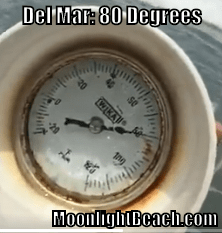
07/26/2018 Fox 5 San Diego News reports: Water temperature hits 80 degrees in Del Mar FOX 5’s Jaime Chambers got a reading on his water thermometer today that he’s never seen in Del Mar — 80 degrees.
(Most North County beach-goers haven’t ever seen water temperatures over 76 degrees)
Chambers, a veteran lifeguard, says it’s the hottest ocean water he’s ever seen there.
The reading comes as a record-setting heat wave bears down on San Diego County. The hot conditions are expected to continue Thursday and persist through Friday night.
The period of extended hot weather, which began Monday and reached its peak Wednesday, could push temperatures into the low-80s near the coast, mid 90s in the inland valleys and mountains, and up to the high 110s in the local deserts, according to the National Weather Service.
Nobody is saying the water temperature is going to cause a hurricane, but…
NASA: What Ocean Temperature Is Needed To Makes Hurricanes Form?
One ingredient is warm water. Warm ocean waters provide the energy a storm needs to become a hurricane. Usually, the surface water temperature must be 26 degrees Celsius (79 degrees Fahrenheit) or higher for a hurricane to form.
According to Weather.gov – There are six widely accepted conditions for hurricane development:
1. The first condition is that ocean waters must be above 26 degrees Celsius (79 degrees Fahrenheit). Below this threshold temperature, hurricanes will not form or will weaken rapidly once they move over water below this threshold. Ocean temperatures in the tropical East Pacific and the tropical Atlantic routinely surpass this threshold.
Here are the rest of the conditions (if you are curious)
2. The second ingredient is distance from the equator. Without the spin of the earth and the resulting Corioles force, hurricanes would not form. Since the Corioles force is at a maximum at the poles and a minimum at the equator, hurricanes can not form within 5 degrees latitude of the equator. The Corioles force generates a counterclockwise spin to low pressure in the Northern Hemisphere and a clockwise spin to low pressure in the Southern Hemisphere.
3. The third ingredient is that of a saturated lapse rate gradient near the center of rotation of the storm. A saturated lapse rate insures latent heat will be released at a maximum rate. Hurricanes are warm core storms. The heat hurricanes generate is from the condensation of water vapor as it convectively rises around the eye wall. The lapse rate must be unstable around the eyewall to insure rising parcels of air will continue to rise and condense water vapor.
4. The fourth and one of the most important ingredients is that of a low vertical wind shear, especially in the upper level of the atmosphere. Wind shear is a change in wind speed with height. Strong upper level winds destroy the storms structure by displacing the warm temperatures above the eye and limiting the vertical accent of air parcels. Hurricanes will not form when the upper level winds are too strong.
5. The fifth ingredient is high relative humidity values from the surface to the mid levels of the atmosphere. Dry air in the mid levels of the atmosphere impedes hurricane development in two ways. First, dry air causes evaporation of liquid water. Since evaporation is a cooling process, it reduces the warm core structure of the hurricane and limits vertical development of convection. Second, dry air in the mid levels can create what is known as a trade wind inversion. This inversion is similar to sinking air in a high pressure system. The trade wind inversion produces a layer of warm temperatures and dryness in the mid levels of the atmosphere due to the sinking and adiabatic warming of the mid level air. This inhibits deep convection and produces a stable lapse rate.
6. The sixth ingredient is that of a tropical wave. Often hurricanes in the Atlantic begin as a thunderstorm complex that moves off the coast of Africa. It becomes what is known as a midtropospheric wave. If this wave encounters favorable conditions such as stated in the first five ingredients, it will amplify and evolve into a tropical storm or hurricane. Hurricanes in the East Pacific can develop by a midtropospheric wave or by what is known as a monsoonal trough.


